

Research
CryoSCOPE advances our understanding of how ice, snow, and permafrost interact with the atmosphere and water systems in a changing climate. Combining state-of-the-art observations, modelling, and artificial intelligence, the project generates knowledge and tools that support climate adaptation and resilience in cold regions worldwide.
Key Scientific Themes

Cryosphere Processes: to improve understanding of streamflow sources, sublimation, and release of greenhouse gases from beneath permafrost and integrate them more accurately into climate models.

Atmospheric Drivers: to reduce uncertainties in radiative forcing estimates caused by aerosol-cloud-precipitation interactions by comparing atmospheric and cryospheric processes.

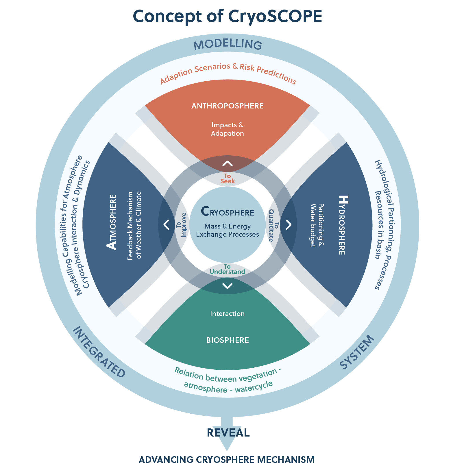
Integrated System Modelling: to advance understanding of the cryosphere-atmosphere-hydrosphere (CAH) system by integrating case studies with coupled modelling approaches. CryoSCOPE tests and validates new modelling frameworks and data-driven tools to better represent small-scale cryospheric processes and improve climate model predictions.

Compound Hazards: to improve risk assessment with better modelling of glacial lake outburst floods (GLOFs), a highly destructive yet poorly understood cryosphere , hazard, drought prediction in snow-dominated landscapes, and permafrost thaw.
Core Research Areas
The project integrates as key components new observation and monitoring techniques, with climate and Earth system and process modelling, understanding compound hazards, and exploiting benefit to society from CryoSCOPE’s predictions and products.
New Observation & Monitoring Techniques
CryoSCOPE combines novel field measurements, satellite data, and advanced models to transform real-time observation of CAH interactions. Using a range of instruments, it gathers high-quality data on snow, ice, water, and atmospheric conditions to support and validate climate and Earth System Models (ESMs). Furthermore, Cryosphere-Biosphere Interactions, partitioning of meltwater inputs into surface water, subsurface water and plant-water uptake to understand the effects of climate change on water availability for the biosphere is to be studied.
- Cryosphere (snow, ice, and permafrost monitoring)
- Atmosphere (meteorology, atmospheric aerosols and gases and energy fluxes monitoring)
- Hydrosphere (water bodies, streamflow, and groundwater monitoring)
- Anthroposphere (hazard and risk assessments)
- Biosphere (plant water uptake from different sources and release)
New observation methods, including muography, will be developed for snow, frozen soil, and lake ice., alongside Stable water isotopes will provide new process understanding on how snow and glacier melt are partitioned into its ultimate fates in streamflow, subsurface water recharge, evaporation and plant water uptake. Nnew modules for ESMs will be established to better represent cryospheric processes in large scale simulations. Additionally, applications for terrain trafficability, hazard maps for glacial flash floods, and enhanced IT infrastructure for machine learning will be created.
Climate & Earth System and Process Modelling
CryoSCOPE integrates observation-constrained models, from detailed process models to ESMs, to better understand CAH processes and predict changes in glaciers, permafrost, and hydrology. It uses Elmer/Ice to training data for machine learning methods and investigate GLOFs and further a groundwater-permafrost model to methane uptake resulting from shifts in local hydrology due to permafrost and glacier retreat. EcH2O-iso to be used to constrain hydrological pathways, comparing these process models with ESMs and leveraging AI-based tools, CryoSCOPE will allow us to model GLOFs and the associated hazards with an unprecedented degree of accuracy and precision, providing useful data to policymakers and stakeholders.
Compound Hazards
CryoSCOPE focuses on understanding compound hazards, where multiple factors combine to create complex risks for mountain and downstream communities. It aims to improve understanding of GLOF and droughts from mountain water storage changes and help identify risk factors and enhance early warning systems.
Product Exploitation
Key industries will benefit from CryoSCOPE’s predictions and products. CryoSCOPE enhances hydropower management with improved snow and ice melt forecasts, energy production optimization, and glacial hazard mapping for GLOFs. It supports agriculture by predicting droughts, water availability, and extreme weather, while helping the forestry sector with winter terrain forecasts, permafrost monitoring, and sustainable forest management strategies.


Funded by the European Union. Views and opinions expressed are however those of the author(s) only and do not necessarily reflect those of the European Union or CINEA. Neither the European Union nor the granting authority can be held responsible for them.


This work has received funding from the Swiss State Secretariat for Education Research and Innovation (SERI) and the Ministry of Earth Sciences, Government of India